

Introduction
As noted above, sub-groups emerged as the primary level of a two tiered approach to stratigraphic grouping originating from the DUA/MoLA school of urban stratigraphic analysis. In this approach ‘subgroups’ are always allocated before ‘groups’, which form a higher level of grouping. However, there is some ambiguity in the academic literature about when and how subgrouping should take place. The traditional DUA approach advocated by Westman and Shepherd (1992) and Hammer (2002) advocates that subgrouping comes first; with subgroups being subsequently placed into groups (thus the analysis reflects the hierarchy of interpretation).
Guidelines for work by Headland Archaeology on the A14 Infrastructure project suggest that It may only be necessary to subgroup stratigraphic contexts where there is a “need to do detailed work to understand specific features. This will be based on when and how individual contexts were created, and may separate contexts relating to a feature’s construction, contexts relating to a feature’s use, and contexts relating to a feature’s disuse, in order to allow a more nuanced understanding of the history of individual features and the overall landscape. This level of subgrouping will only be carried out where there is the information to do so, and where this level of detail will aid interpretation and understanding of the site (it will not be necessary for all groups)” (MoLA Headland Infrastructure, 2020 p16).
[Video] Grouping and subgrouping process as described in A14 guidance for Stratigraphic Analysis on the A14 road scheme infrastructure project (with thanks to MOLA Headland Infrastructure and National Highways)
Hammer (2002, Section 3.3) suggests then that a subgroup represents the lowest level of an interpreted assemblage of stratigraphic units or contexts. In this sense a subgroup is the lowest order of interpretive grouping that might be applied to the basic stratigraphic sequence diagram. Subgroups are sets of closely related contexts of human activities, which will later be linked into groups” and should “contain stratigraphically closely related contexts that form part of the same ‘process’ or” a related interpretive feature, “in other words, of the same processual ‘small phase’ event such as construction, use (of the surface), or disuse and/or abandonment” (ibid.).
Hammer’s approach is also reflected in the Archaeology South-East Post Excavation Manual, which explicitly suggests that the concept of sub-grouping aims to achieve several objectives:
- Helping to reduce the amount of data by organising contexts into units based on construction, use, and disuse
- Identify which contexts are being used to date a feature
- Allowing for the provisional dating of features through association when there is no direct dating evidence available (Swift 2011, 12).
Stratigraphic subgroups can also serve as a narrative framework in archaeological analysis, offering a structured interpretive lens through which the site development can be presented. Subgroups can be used to create individual text sections, each telling the story of a distinct activity. This allows for an articulate reconstruction of how various interpretative elements at the site came together over time, an approach that extends beyond primary physical categorisation of deposits and processes.
Methods
Swift (2011) advocates that (henceforth) subgrouping (or primary grouping) in stratigraphic analysis involves organising contexts into distinct units based on their construction, use, and disuse (or CUD; a higher order terminology originally developed by the DUA) phases. The process starts by considering the context matrix, even if there are isolated strands of matrix or no inter-cutting features on the site. This is in line with Hammer’s (2001) assertion that the objective of subgrouping is to understand the contexts within the processual cycle of activity and land use.
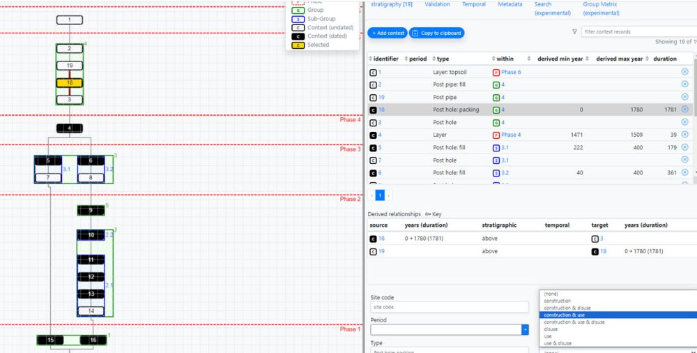
In principle any sequence of stratigraphic contexts can be subgrouped, using the above criteria. However, to avoid complication, stratigraphic grouping should follow these 3 simple principles (expanded in the general rule for groups below):
- Where subgroups are used all stratigraphic contexts can be subgrouped, however it may be that not all contexts need to be subgrouped. For example an isolated floor surface or a ditch cut may just stand alone as a feature in its own right (but note: this has an implication on the construction and layout of a derived group matrix and there is a school of thought that argues that this should not be allowed). Very simple sites or areas may not need grouping at all (since the process is about simplifying the stratigraphy, why add another layer of interpretation if it is not necessary?).
- A stratigraphic context can only be allocated to one stratigraphic subgroup; it is either in or out, there can be no sharing of contexts or else groups will overlap.
- Subgroups should effectively respect the stratigraphy of your area. The relationship between subgroups should obey the same rules as your basic stratigraphic matrix (above, below or the same as). In this respect the stratigraphic subgroup matrix is an abstraction of your underlying stratigraphic matrix.
It should be noted that whilst the criteria for allocating subgroup numbers are meant to be flexible, one should always be explicit about which contexts are subgrouped and why. Whatever else, be mindful of Rule 2 above, stratigraphic subgrouping will not work if it does not respect your stratigraphic sequence.
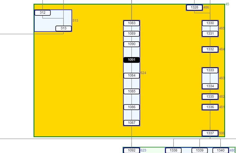
Mechanically the simplest way to assign subgroups by this logic is to quite literally draw boxes around associated contexts in the stratigraphic matrix, or code up an open area plan (on horizontal sites where a matrix may be less relevant). Like in the basic stratigraphic matrix, if the contexts within a subgroup are split stratigraphically (i.e. by later truncation of the sequence, or across different excavation areas or trenches), then two subgroup numbers should be allocated and equated.
Bottom-up or top-down?
Subgrouping in the stratigraphic sequence can be approached from the bottom-up or the top-down. The choice of approach will likely depend upon the specific site and the complexity of the sequence under analysis. The bottom-up approach involves starting from the bottom of the sequence and progressively subgrouping contexts based on their construction, use, and disuse phases (common in the DUA/MoLA approach). The numbering of subgroups should therefore follow the chronological development of the site, allowing for a systematic understanding of the site’s history and the relationships between different activities. From a narrative perspective this may be easier from the bottom-up (i.e.numbered earliest to latest).
According to Hammer (2001) it is important to begin by examining the longest strand in the stratigraphic matrix. It is common to encounter side branches, or ‘floating’ strands, that terminate beneath a sealing context known as the nodal point (often extensive contexts which seal a large number of earlier stratigraphic contexts, or support a large number of later ones). These may indicate significant stratigraphic events, marking the need for a new subgroup. This bottom-up “critical path” approach to stratigraphic analysis, is also advocated by Roskams (2002). It is, according to Hammer (2001) important to comprehensively understand and incorporate all side branches into one or more subgroups before proceeding further up the sequence.
This approach appears to be primarily practical in nature, however, advocates of a bottom-up approach to subgrouping would argue that starting from the bottom of the sequence is also crucial to account for potential slumping or subsiding of earlier pit fills (for example), which can impact the levels of higher layers. This approach helps in understanding the relationship between contexts and identifying potential subgroups.
On the other hand, the top-down approach begins with the overall understanding of context spatial organisation (in a GIS for example) and subgroups based upon a holistic understanding of the way contexts are distributed and the interpretation of their function. This approach provides a broader perspective on site development and facilitates the identification of key chronological markers across a large area, being particularly effective in rural contexts where the stratigraphy is more horizontally distributed. Crucially, in the approach there is a reduced need to work with a formal Harris Matrix (except perhaps in more complex areas of the site), rather the subgrouping process is done spatially directly on the mapped outputs or in an intrasite GIS.
What makes a subgroup?
There is a lot of debate about what actually should constitute a subgroup (see resources below), but the general consensus is that the subgroup is a small (or the smallest) unit of grouping representing a discrete archaeological feature composed of closely related contexts. These are often defined as organisational, or project specific vocabularies, but can generally be seen as falling into the broad Construction/Use/Disuse (CUD) convention. This variation of definition means that it is critical to be explicit about what makes a subgroup from the outset of the grouping process. However commonly they might include:
- Natural Geology: The primary and untouched geological state of the site.
- Levelling for Construction: Thick deposits with an even surface containing cultural material, such as charcoal and artefacts, indicating preparation for construction.
- Construction: Features like trenches or linear cuts containing walls, timber or clay sills, rows of posts or stakeholes.
- Pits: The cut and fills related to the original construction and use form one subgroup.
- Quarry Pits: The cut represents the primary usage and forms one subgroup.
- Masonry-Lined Wells/Pits: The construction elements form one subgroup.
- Walls: The construction cut, any foundation, wall, and construction backfill form a single construction/use subgroup.
- Floors and External Surfaces, Routeways: Construction make-up layers, the surface itself and occupation debris should form one subgroup representing construction and use.
- Postholes, Stakeholes: The cut and the fill used to date the feature should be one construction/use subgroup, unless there is evidence that the fill is later than the construction.
- Ditches, Gullies, Drains: The cut and the primary and possibly the secondary fills should form one construction/use subgroup.
- Use/Occupation: Indicated by thin, dark spreads, patchy layers or middens of mid/dark grey silts containing charcoal, pottery, bone, etc.
- Floors: This refers to constructed flat surfaces within a built structure, such as a building or settlement. They are typically made of compacted earth, stone, brick, or other materials, and their presence can indicate the internal layout of a past structure. Subgroups within this category may include different construction phases and periods of use or disuse based on the dating of the surface and the debris associated with it.
- Occupation Accumulation: This term refers to deposits that result from human activities within a site over a period of time. Such deposits can include waste from domestic activities, such as food preparation, tool-making, or crafting, and can offer valuable insights into the daily life and practices of past inhabitants. They are usually characterised by dark layers or patches of soil enriched with organic matter and various artefacts.
- Structured Deposits: These are intentional deposits of objects or materials placed in a specific manner or pattern, often for a specific purpose. The purpose can vary widely from practical, like waste disposal or storage, to symbolic or ritualistic. These deposits may include a wide variety of materials, including pottery, animal bones, human remains, or other artefacts.
- Pyrotechnic Installations: These are structures or features associated with the use of fire or high temperatures, such as hearths, ovens, kilns, or furnaces. These installations can provide information about various human activities including cooking, metalworking, pottery firing, or other forms of manufacturing.
- External Area: Characterised by gravel/sandy makeup and occupation debris, middens, with pits, posts, stakeholes, drain or gully.
- Road or Path: Linear gravelled area with compacted trodden surface, sometimes raised at the centre and with side ditches.
- Alteration within Structure: Modifications made within an existing structure, such as new floors, partition/enlargement walls.
- Waterfront Construction: Timber or stone structures along river revetting or reclamation deposits.
- Disuse/Destruction: Deposits sealing wall lines or slots, extensive fire debris above internal and external areas, indicating a period of disuse or the site’s destruction.
- Pits: Upper fills form another subgroup(s) if the dating deems them to be later than the primary / secondary fills, or they are obviously later events.
- Quarry Pits: The fills should form other use and/or disuse subgroups.
- Masonry-Lined Wells/Pits: Backfills should form separate subgroups as these represent the disuse, or secondary use of the feature.
- Walls: Repairs, additions, doorways added etc. are secondary construction/use subgroups.
- Floors and External Surfaces, Routeways: If there is a variance between the dating of the surface and the debris, then these should form separate construction/use and use/disuse subgroups.
- Postholes, Stakeholes: If there is evidence that the fill is later than the construction, it forms a separate subgroup.
- Ditches, Gullies, Drains: Upper (silting, slumped-in etc) fills potentially with later dating evidence should form other use/disuse subgroup(s).
- Abandonment: Minimal changes, erosion and thin accumulations of weathering, possibly indicating the site’s abandonment.
Assigning contexts to subgroups
Following is a workflow summary on how to assign stratigraphic context to subgroups:
- Subgroup Numbering: Assign numbers to subgroups in a sequential manner, based upon your organisational convention. On vertical stratigraphy (urban sites) begin at the bottom of the sequence and move up. On horizontal stratigraphy (rural sites) systematically work through the plans or GIS.
- Grouping: Group elements of construction, use, and disuse together on the context matrix, or matrix strands for non-intercutting features. Number these according to the previously explained rationale to form sub-groups. If you encounter any challenges during this process, seek guidance from post-excavation managers.
- Sub-group Description: As you form each subgroup, concurrently add the descriptions to the Land Use Register (if appropriate).
- Creation of Date-Phased Subgroup Matrix: If appropriate redraw the date-phased subgroup matrix or strands (dating may more usually be appropriate at the group level in two tiered grouping systems), or annotate the groups (by circling or otherwise highlighting the stratigraphic matrix. This could be done manually or using a relevant tool. Altering the relationships of the underlying matrix based upon dating would only occur in exceptional circumstances. This subgroup matrix should be created with reference to:
- The stratigraphic relationship of the archaeology: Arrange the matrix in ascending/descending order of time, with the latest features at the top and earlier ones below (as you would the underlying Harris Matrix).
- Spot dates from datable finds: Organise these in the same way as the stratigraphic relationship, with later features at the top, and earlier features below. Sometimes, the evidence from dateable material may require you to reverse the original decision of ‘what cut what’ made on site.
- The spatial locations of the archaeology: Ensure proximate features are near each other on the matrix to the left or right, where possible and according to cardinal points.
Some further points to note:
- Consideration of primary observations and spot dates in subgrouping: This is an interpretative process and as such it is important to carefully consider, during the grouping process, any primary observations (colour, texture, inclusions, etc.,) as well as other descriptive, metric and interpretive observations made by the excavator in the field.
- Debate over context inclusion in groups: There is some debate as to whether every context needs to be in a group (as outlined in DUA/MoLA guidance. This will depend upon your organisational or project post-excavation protocols and should be decided in advance of stratigraphic analysis.