

Overview
“Although a complete excavation record should have been established as far as possible on-site, both time pressures and practical problems, plus matters such as cross referencing, mean that certain aspects will need to be finished after the event” (Roskams 2001, 241).
For most excavations the post-excavation process must begin with a process of consolidating and validating the site archive records that have been compiled during the on-site recording of the excavation. According to Historic England’s Management of Research Projects in the Historic Environment (MoRPHE) framework, this forms part of the “assessment of the potential of the results, or products to achieve the Aims and Objectives of the project” (Lee 20215, 10). In a single context methodology this involves ‘checking the record’ by reviewing the main written, graphic, photographic and (more recently) digital components. Record checking would ordinarily involve the systematic review and validation of the primary data (context sheets, plans, databases, images, etc.) to make sure that there are no errors or omissions, and the cross-checking and cross-referencing of registers to ensure the integrity of the data-structure and the unique identifiers associated with the archive. In most stratigraphic recording systems (such as: single context recording) this will usually hinge upon the unique ‘context number’ associated with each stratigraphic unit, but may also include an array of finds numbers, sample numbers, photograph or drawing numbers, survey control records, and indeed spreadsheets or databases (e.g. see examples in Stratigraphic Documentation Outputs listings).
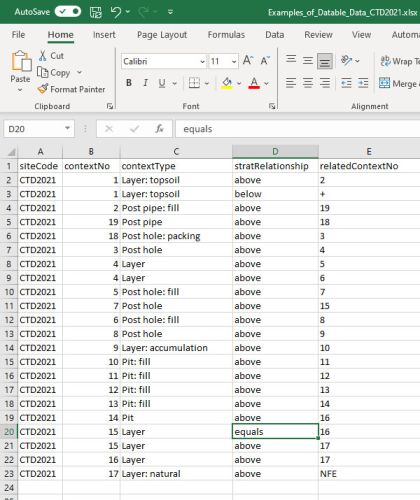
This process of checking the record is about checking archival integrity for the subsequent analysis of the sequence and the finds it yields. Hammer (2002, Section 2.2) notes that:
“Although analysis may bring changes to the original (checked and amended) interpretation, the original state of a site record must remain unaltered or as a minimum, the original version must be readable and any changes must be initialled and dated. Reinterpretation during analysis will often occur and be discussed in the report. It has become common practice that all records from excavation (and post-excavation) have their own integrity and must be indexed and accessible for future work.”
As a minimum record, all stratigraphic relationships (above, below, equals) between identified stratigraphic units (SUs) should be recorded in some format, using stratigraphic principles (Harris 1989). This should clearly record the relevant relationships between every context that is to be part of the analysis.
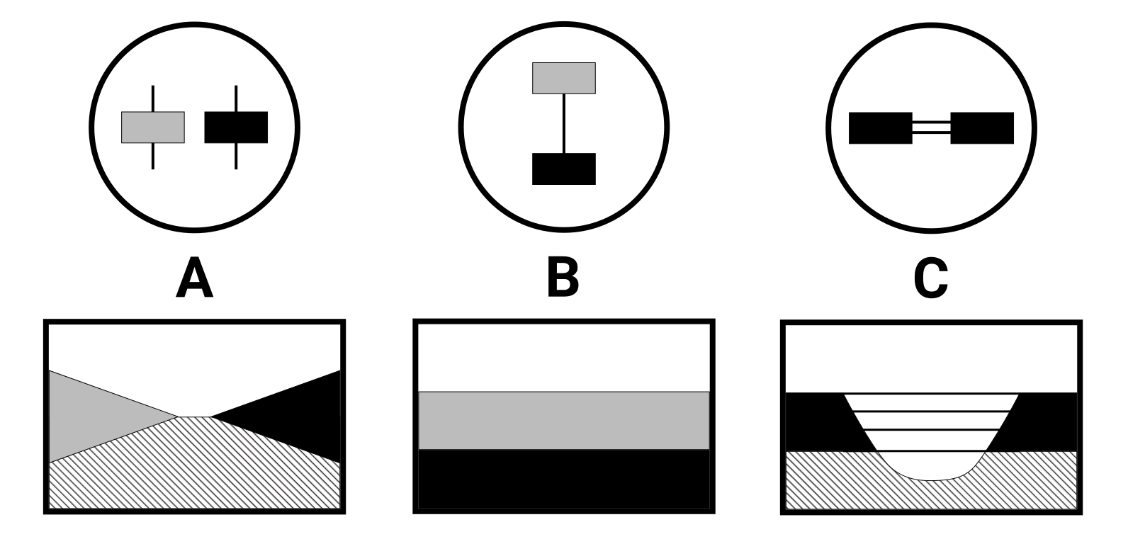
Using a Harris Matrix diagram is a common and highly effective method and organisational tool for documenting on the context recording sheet the stratigraphic relationships observed by the original excavator and for cross-checking of data retrieved in plan against the evidence of any sections, any of which can show disparities between separate elements of the primary record.
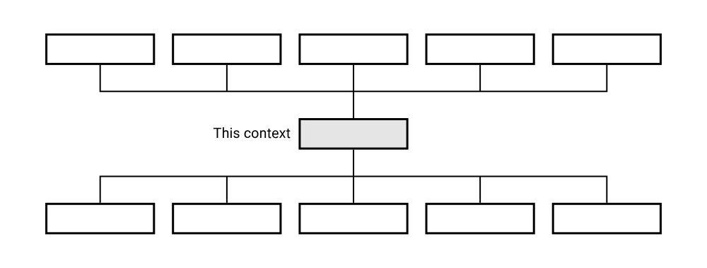
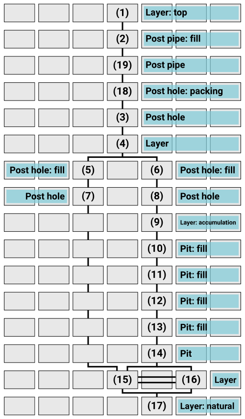
Constructing and completing the matrix diagram also helps direct the stratigraphic analyst towards any areas of contradiction. These can be seen as intriguing and exciting challenges, rather than problems, and they invite the archaeologists to think more closely about their assumptions. Once these challenges have been addressed then the Harris Matrix provides a visual synthesis of the sequence of deposition or truncation events from which one can start interpreting meaning.
The matrix provides a means of addressing assumptions and can provide focal points for critical discussion during analysis. The generation of a stratigraphic matrix is not simply about the end product or a diagram, but rather the compilation of a stratigraphic record is part of a process, as Harris himself says, “to understand stratigraphy as its excavation is happening”.
When deciding in analysis upon the need for a site-wide Harris matrix diagram, its relevance and usefulness must be considered based on the nature of the investigation and the complexity and scale of the archaeology encountered. For stratigraphic records with any depth or complexity a matrix diagram provides a great tool to organise and sense check the primary record.
The stratigraphic principles set out by Harris (Harris 1989) are fundamental and should be adhered to, but not all archaeological investigations may necessarily need a site wide and phased Harris matrix diagram to be drawn, if there is literally no stratigraphic record to analyse. Or a fully phased matrix diagram may only be most useful for specific areas of stratigraphic complexity within an otherwise very shallow, or uniform, site.
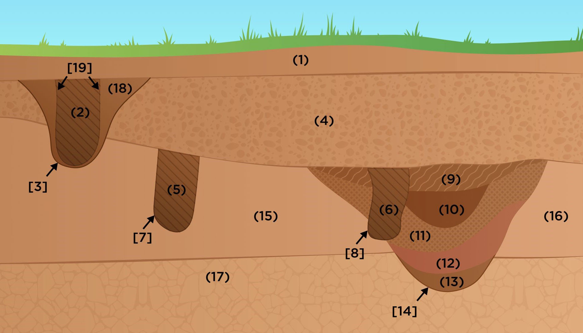
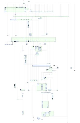
The purpose of a Harris matrix method is to provide an initial sense-check of primary recording. The end product, the matrix diagram, provides a visual representation of the stratigraphic sequence. It is central to understanding the chronological sequence of deposition and truncation and is a fundamental tool in understanding the development or changes on a site over time.
Even on what one may interpret as a simple site, the matrix acts as a means of organising, and most importantly thinking about data, making sure recorded data is consistent. On some sites, the stratigraphic relationships may be seen to be straightforward but one should still critically examine any assumptions. Without informed critical thinking about stratigraphy then simplistic generalist interpretations may become a norm and leave no latitude for understanding the extraordinary, or even the ordinary, in different contexts. The tendency for over simplification is to be guarded against as much as the tendency to make it more complicated than it is.
In deeper stratified sites, most often in urban situations or deeply stratified rural sites, that exhibit vertical complexity in the sequence, ‘running matrices’ or draft Harris matrices should have been created on-site, to support the initial observations and interpretations of the excavator. These draft matrices serve as working documents and are continuously updated as excavation progresses. They allow archaeologists to document and analyse perceived stratigraphic relationships in real-time, and can inform decision-making on excavation strategies.
This earliest period of post-excavation record checking then, is the point at which the Harris Matrix might be initially compiled from the primary record and on-site draft in something approaching its final form (so-called ‘running’ matrices are drawn out either by hand or digitally using specialised tools). Without careful checking the records may produce circular stratigraphic relationships or “H” relationships which, if not checked at the trowel's edge, will cause greater problems later.
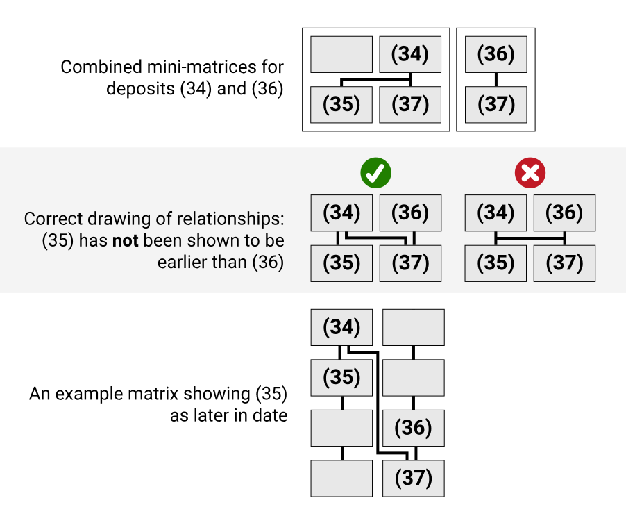
For shallower sites, with less ‘vertical’ depth of stratigraphy (and more spatial horizontality in the contexts recorded), often these types of sites present an opportunity to make good use of Geographic Information Systems (GIS) for managing the site’s spatial record, together with temporal and stratigraphic documentation. In this case the process of consolidating the archaeological archive and preparing for analysis is characterised by slightly different but intimately related steps. A key aspect of this process is the thorough examination and critical understanding of any digital survey or site plan, ensuring its accuracy and completeness. Survey control and surveyed data serves, in these instances, as the verification of the location of units of stratigraphy and the basis for “grouping” and then “phasing”, and the correctness of the digitised spatial record is crucial to any stratigraphic analysis. The use of GIS technology has become increasingly common in archaeology for this purpose, however, regardless of the GIS implementation, the verification of recorded relationships presents its own challenges in the digital realm. It entails meticulous scrutiny of the entire database to ensure its coherence and functionality and underscores the need to carefully document running matrices as the site is being excavated. The use of GIS technology has become increasingly common in archaeology for this purpose. However, regardless of the GIS implementation, the verification of recorded relationships remains a laborious and difficult process in the digital realm. It entails meticulous scrutiny of the entire database to ensure its coherence and functionality and underscores the need to carefully document running matrices as the site is being excavated.
In analysis, the decision to construct a site-wide and phased Harris matrix should be based on an informed and reflexive assessment of the site's stratigraphic complexity and the specific research objectives, including any potential to associate stratigraphy from known excavations nearby. In a time limited excavation situation it may be necessary to weigh the potential benefits of using a collated matrix diagram for site-wide analysis against the time and resources required to create and maintain it.
Adaptability and flexibility in choosing the most suitable methods for stratigraphic analysis based on the archaeology encountered should ensure that the overall methodology employed aligns with the specific requirements of each archaeological site.