

Generally when completing a site record, either with typically simple spatial stratigraphy on shallower “topsoil/natural sites” or more complex sites with deeper vertical stratigraphy, there are iterative stages that the supervisor should undertake. Supervisors or excavators should cross-check context sheets and plans, sections, photography and samples for primary data consistency to ensure there are no internal contradictions. Draft or ‘running’ matrices should be critically checked so that a 4-dimensional conception of “what is going on” can be achieved (note: ideally, especially on simpler sites, much of this work will have been completed in the field so this may be little more than a straightforward data validation check).
It can be useful to consider the nature of identified events, as a working interpretation, but this should not be fixed and should always be open to critical self-analysis. If one is confident in the interpretations and they are justified then one can begin to create subgroups (and/or groups) based on interpreted events or activities identified in the stratigraphic record. The creation of subgroups, utilising this framework of thinking is really useful, but it is an interpretive move and must be underpinned by explicit and overtly stated sets of justifications. Ideally further analysis would continue after spot-dates are returned from specialists and subgroups and groups (as appropriate), can be finalised.
The construction of the stratigraphic matrix is always closely linked to the record checking process and can be broadly divided into a few key tasks depending, again, on the type of stratigraphic recording system adopted on site. For single context recording, the process generally follows the following pattern :
- Compiling a plan matrix (single context planning only)
- Checking and validating the stratigraphic relationships.
- Correlating stratigraphic contexts.
However, with the uptake of spatial technologies to handle the spatial data on excavations 5m by 5m plans might be digitised and merged in GIS before the excavator attends to the matrix; in which case the plan matrix is less critical (serving as little more than a failsafe, to check ambiguities). Furthermore on excavations where much of the recording is handled digitally, either through primary data acquisition (by survey or 3D recording), or digitised during or directly on leaving site then first steps would be to systematically consolidate and verify the written archive, by cross-referencing the digital survey or site plan with the physical artefacts and stratigraphic relationships collected during excavations noting any discrepancies or missing information. Use of GIS technology can significantly aid in visualising the spatial relationships and contextual information of the recorded features and context.
Traditional Land Use diagrams and GIS-based spatial analyses may therefore be understood as related forms of interpretative synthesis, translating stratigraphic, depositional and distributional evidence into a reasoned account of how spaces were used, modified and reworked through time.
Compiling a plan matrix (optional analogue single context method only)
The process of checking and validating the basic stratigraphy will vary depending on the complexity of the site and recording system used. Pro-forma single context planning sheets generally have a space for documenting a plan matrix for the grid square being recorded. Therefore if a strict single context recording system has been deployed in the recording of an excavation, then a common first step in this process of checking the stratigraphic record and creating a site matrix, is to collate a separate plan matrix for each 5m grid square excavated. These can then be cross-referenced and combined to form a complete plan matrix for the whole site or area. This would form a basis for a fully phased matrix, which would be filled out with any context numbers which may not have been planned (e.g. contexts only recorded in section, unplanned fills of cut features), before being checked and validated (see below). But it should be noted that this approach can present challenges and create more work for the stratigrapher, and piecing together ‘blocks’ of matrix is harder in post-excavation. As noted above, plan matrices are generally rendered unnecessary by digitising the plans and using a GIS. As such it is worth reiterating again that it is easier and more logical to produce the complete stratigraphic matrix as you excavate (as a ‘running’ matrix) wherever possible.
Checking and validating the stratigraphic relationships
When a matrix is needed for stratigraphic analysis, whatever the mode of graphical or spatial recording and whether a plan matrix has been recorded or not, the excavation team should have kept a draft or ‘running’ matrix of excavated units on-site, compiled as stratigraphic contexts were defined, but these may be incomplete and/or area specific (i.e. focused upon more complex areas of excavated stratigraphy). If so, the next task for the stratigraphic analyst (often the field director, project officer or area supervisor) will involve transposing the stratigraphic relationships from the written (or digital) excavation archive records into a final draft matrix diagram and checking the validity of these relationships against the graphic or spatial record (whether these are pro-forma context sheets and draft matrices or digital stratigraphic relationships in a database and matrix software). Ambiguous stratigraphic relationships might be further checked against the photographic archive, site diaries and interpretative notes, 3D models, or other aspects of the archive. At the end of this process the aim is to produce a clear and final Harris matrix diagram for further analysis, the relationships which it articulates should be updated in the primary record. It should also be clear in records where the top and bottom extents of the matrix are and consistent conventions should be used to show if the bottom of the matrix represents simply a limit of the extent of excavation carried out, perhaps due to building limits (eg. NFE - No Further Excavation), or the actual lowest extents of Anthropocene activities (e.g. SoN - Surface of Natural).
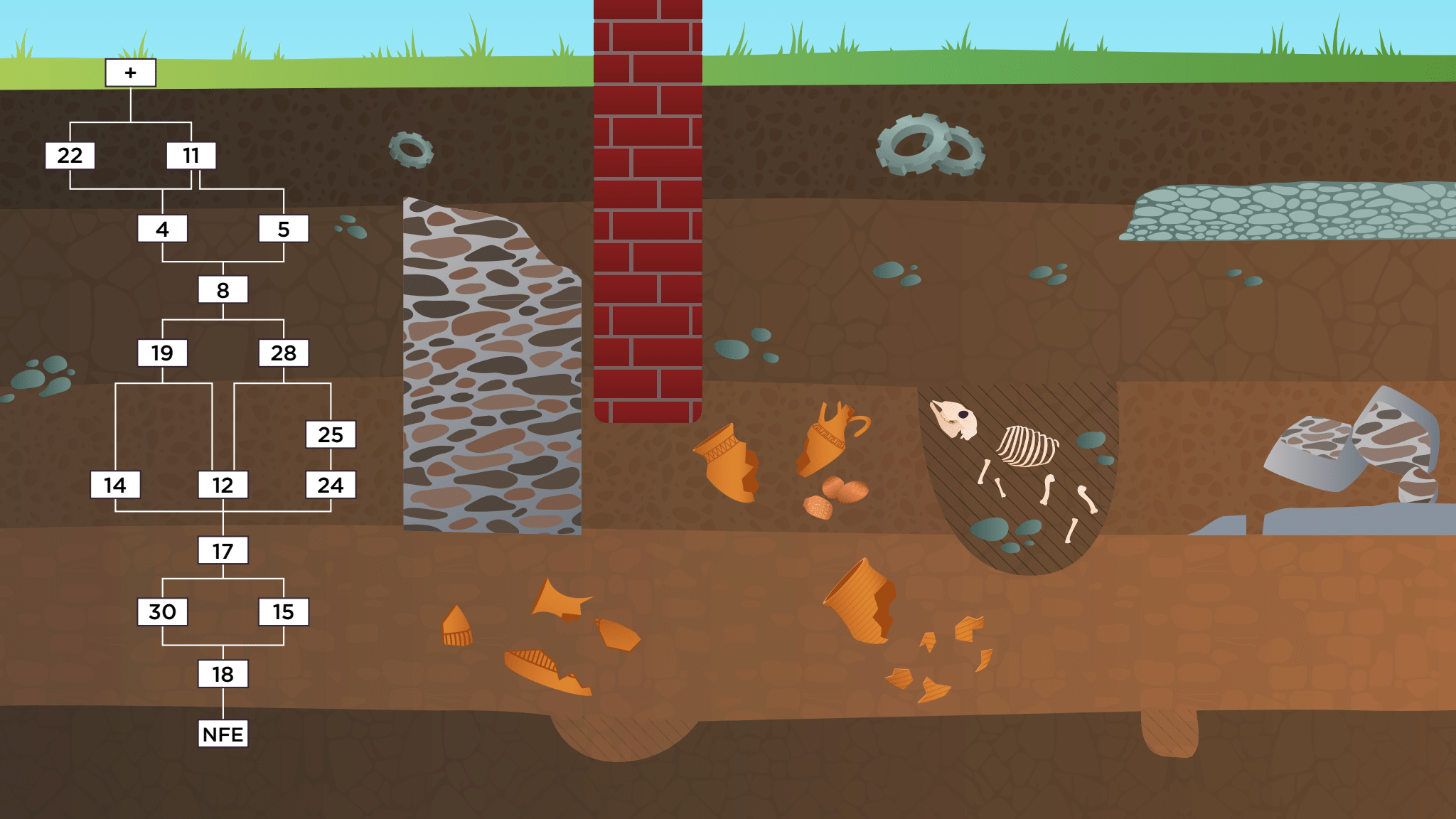
The most commonly occurring protocol for denoting the top of the stratigraphic sequence is the use of the '+' symbol to denote the uppermost context (e.g. in MOLA archives). In some archives, this '+' corresponds to a 'top of sequence'. In other examples (mostly from rural excavations), the term 'Topsoil' denotes the uppermost context in the stratigraphic sequence.
A common protocol for the bottom of the stratigraphic sequence is the term 'NFE', which is an abbreviation for 'No Further Excavation'. Other terms encountered are 'limit of excavation', 'excavation extent' and variations on a similar theme.
It would be useful to adopt a uniform way of representing the bottom of an excavation in a Matrix diagram and the associated data records, once archaeologists have finished excavating. Similarly, various terms have been used for where the surface of underlying geological layers and non-anthropogenic strata were encountered. Most commonly 'Natural', or 'Surface of Natural' (SoN) is used, but it is not always clear if archaeologists are consistent in distinguishing between 'NFE' and 'SoN'. On many sites, particularly in urban locations, archaeologists finish the excavation at NFE and it would be useful within development schemes to record whether SoN has also been encountered.
Matrix Construction
There are some considerations about when and how to construct the Harris Matrix from the top of the sequence down, or from the bottom up.
- Constructing from the top down
This approach involves starting with the most recent or uppermost layers of the stratigraphic sequence and progressively working downwards. This is most often the way in which running, partial, or draft matrices are constructed while the excavation is still ongoing, as they represent the order of excavation on site. In this way a matrix is built in the sequence that the stratigraphic units are encountered in the ground. As such the matrix diagram is used for maintaining stratigraphic control of the excavation archival record. Constructing from the bottom up
This approach involves beginning with the earliest or deepest layers of the stratigraphic sequence and moving upwards. It can therefore only be done efficiently once excavation has been completed of all the contexts to be included in the diagram. Working through and checking an already complete stratigraphic relationships from the bottom up can be advantageous when trying to make sense of more complex stratigraphy, as it will reflect the order of deposition of the stratigraphic sequence and essentially underpins the structure of interpretive Phases and the stratigraphic narrative (which should be written following the order of deposition). Phase numbering is usually applied starting from earliest levels moving upwards to the latest levels in the matrix.Insert suitable illustration if available
Correlating stratigraphic contexts
Simultaneously the stratigrapher will be looking for correlations between contexts. That is, those units which might be aligned horizontally in the matrix on the basis of one of three (normally) forms of association:
- Shared space (in time) (i.e. a series of pits which were cut at the same time)
- Shared function (i.e. a cluster of post holes that formed a structure)
- Identicality or former wholeness (i.e. a single spatiotemporal deposit which was divided by a later truncation, or only excavated in separate segments) - see illustration
(for an extended discussion of correlation see: Roskams 2001, 246-253)
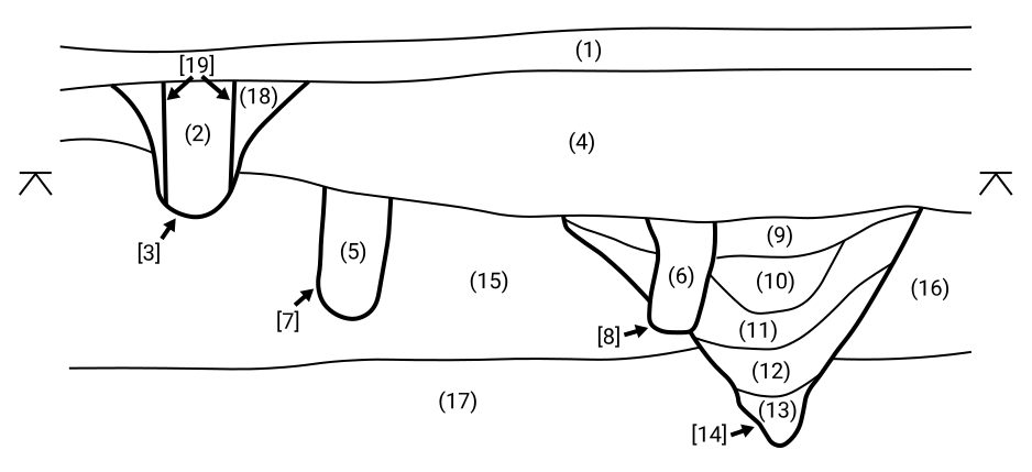
All correlations are a form of interpretation of the stratigraphic sequence and should be justifiable, many may (ideally) have been noted in the primary record as they were excavated, some may be assigned in post-excavation as the stratigrapher constructs the record and builds an holistic understanding of the sequence. It should be noted that Harris also explores the importance of correlations (Harris 1989, 105-107) and he explicitly recognises the correlation of “a once-whole deposit or feature interface” (association 3 above) as one of the three core stratigraphic relationships in the Harris Matrix, alongside having no direct relationship with any other stratigraphic unit, or being in superposition (ibid., 36). This might imply that the first two associations, of shared space and shared function, are more interpretative in their fundamental nature and may not be recognised by purists as a core stratigraphic relationship. These stratigraphic correlations are often represented in stratigraphic records as ‘=’ or double headed arrows in the matrix diagram.
Insert suitable illustration if available
In practice elements of this process may blur as practitioners often do this in conjunction with the process of grouping (and perhaps phasing), especially upon sites where units are distributed over a larger horizontal area. So, in fact, the process of validation and correlation is not necessarily sequential, but rather may be iterative. Practitioners may often take an area of the site, look at it, check it and understand any stratigraphic relationships, whilst simultaneously grouping and phasing that area, before moving on. The result of this process is a checked and validated stratigraphic sequence diagram where strings of contexts are ordered according to the interpretive correlations as defined by the stratigrapher.